What is a Conservation Plan?
A conservation plan encompasses all of the natural resources on your land which can generally be categorized into soil, water, air, plant, animal, and human considerations. There are many benefits to a conservation plan but two main goals will be achieved through the implementation of a plan: the control of soil erosion and the maintenance of local surface and ground water quality.
For the next several years the MSWCD will be focusing efforts to help improve water quality on the Headwaters of the Pudding River. This program is a collaboration with the Oregon Department of Agriculture to help improve water quality runoff from agricultural lands. If you are in the focus area and would like information on conservation resources that we offer please contact office@marionswcd.net or call 503-391-9927.
Benefits of a Plan
- Protection of soil and farm productivity.
- Protection of water quality.
- Improvement of soil fertility.
- Management of soil moisture.
- Saves you money over the long term as your land becomes more productive.
- Ensures better natural resource quality for you, your animals and your neighbors.
- Enhances open space and wildlife habitat.
- Improves animal health.
- Contributes to plant health and vigor for desired plants.
- Makes your property more attractive and promotes good neighbor relations.
- Promotes health and safety of your family.
- Helps you comply with Ag Water Quality Plan, SB 1010.
- Increases property value.
Starting the Conservation Planning Process
Landowners Responsibilities
- Provide access to property.
- Walk the property with the planner.
- Participate in each planning process step.
- Voluntarily follow Conservation Plan.
- Choose and apply conservation practices.
- Monitor effects and re-plan if necessary.
Planner Responsibilities
- Develop conservation plan with you.
- Provide technical assistance.
- Provide information about possible financial assistance.
- Assist with monitoring progress and providing documentation.
- Evaluate monitoring and provide re-planning technical assistance if necessary.
Focus Area: Head Waters of the Pudding River Area – Map
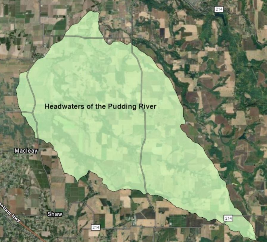
Part of the SWCD’s ongoing partnership with the Oregon Department of Agriculture (ODA) involves working to solve natural resource concerns within Agricultural Water Quality Management Areas (AWQMA). The Marion SWCD works within the AWQMA known as the Molalla-Pudding-French Prairie-North Santiam Area Plan. The area encompasses a lot of the district where we put conservation measures on the ground. To better gauge the effectiveness of the work going on in management areas, we will break down the larger area into smaller watershed units called Focus Areas. For the next several years, our focus area will be the headwaters of the Pudding River. This area is roughly 22,000 acres, extending from the upper South Fork of the Pudding near Silver Falls Highway and Carter Road near Sublimity, northeast toward Macleay and Durbin, then east to the confluence of Drift Creek and the Pudding near Selah Springs Drive and southeast along Cascade Highway.
Our efforts in this area are focused on improving the soil runoff conditions from agricultural practices that impact the headwaters of the Pudding River. We are engaging local landowners and providing resources and grant funding to get conservation cover happening on the ground. Cover cropping, filter strips, field borders, and riparian buffer enhancements are all part of the toolbox. If you are a landowner in this area and would like to meet with a conservation planner to find out about resources available, please contact us today!
Howell Prairie Creek – Pudding River Strategic Implementation Area (SIA)
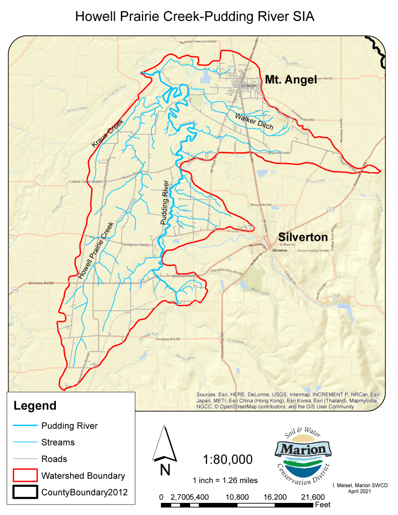
In Fiscal Year 2020-2021, the Marion SWCD took on the ambitious task of working with the Oregon Department of Agriculture (ODA) on a Strategic Implementation Area (SIA) in the Howell Prairie Creek/ Pudding River Watershed. This initiative is funded by ODA to concentrate technical and financial resources into a specific geographic area to address agricultural water quality concerns.
The selected Strategic Implementation Area includes 17,397 acres of the Howell Prairie Creek-Pudding River Watershed. The watershed is located 7 miles east of Salem and encompasses the Pudding River and 3 major tributaries: Howell Prairie Creek, Kraus Creek, and Walker Ditch. The SIA includes lands within the watershed upstream of the confluence with the Little Pudding River, including most of the town of Mt. Angel and a small sliver of Silverton.
For this project ODA has identified properties we may be able to provide resources to. A campaign is underway to reach these property owners and provide them with the resources they need to reach compliance with Agricultural Water Quality area rules.
Part of this project involves a water quality monitoring plan. Working with local partners and other agencies, such as DEQ and the ODFW, we will submit a proposal to monitor for water quality parameters relative to the work we are doing in the watershed, such as sampling for turbidity to see if the best management practices we are implementing for erosion control are having a positive impact on water quality. This multi-year project runs through 2025.
Related Resources
Contact Us
To start a Voluntary Conservation Plan, contact a conservation planner. Our Ag Conservation Planner can connect you with the right person.